Saturday, December 31, 2011
Birds Falling From the Sky Once Again in Beebe, AR
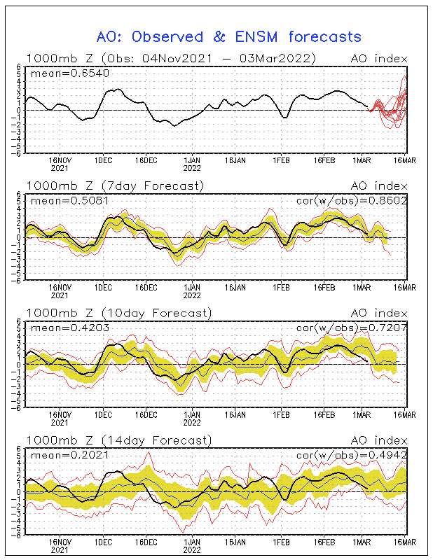
Police in Beebe, AR report that so far, 40-50 birds have falling from the sky there. This happened the same date last year, when thousands of those same type of birds fell from the sky. They think that the cause of the birds falling from the sky are the loud fireworks scaring the birds. You can all see a radar image where there is no precipitation falling, but birds are falling, being picked up by the radar (picture from Brad Panovich).

Friday, December 30, 2011
2012 Atlantic Hurricane Forecast: First Edition
I know it's pretty early to be predicting the hurricane season but here is my prediction. I think this hurricane season will be slightly less active then last year, but still an above average year.
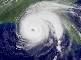
2012 Hurricane Season
Tropical Storms Hurricanes Major Hurricanes
15-18 8-11 3-5
A
V
E
R 11 6 2
A
G
E
2011's Hurricane Season
- Tropical Storms- 19
- Hurricanes- 12
- Major Hurricanes- 5
Thursday, December 29, 2011
NAO Expected to Go Negative Mid January, Also Discussion on Snow
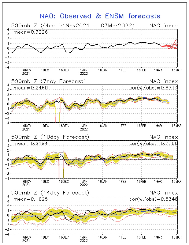
The NAO is expected to go negative around the 11th of January. This might cause a Greenland Block, which would give the East coast more persistent cold air. This is what happened last year, locking the cold air in place. Of course, there is other factors like the AO and PNA tht could also effect the weather pattern. If the AO goes negative while the NAO goes negative, that will also enhance our cold air. We also need the PNA to stay positive, which it will stay through the first part January. It will go negative mid-January. If the Southeast gets snow or not depends on the storm tracks. A storm just off the East coast, a classic Noreaster, would be one of the best chances of snow for the Southeast, especially the Carolinas.
Wednesday, December 28, 2011
Arctic Air Will Arrive Around the 4th of January, GFS Model Looks a Bit Intresting
Artic air will plunge south around the 4th of January. Tuesday, many areas will only make it into the low to mid 40's. The rest of next week, the cold pattern continues. Some time during the week, temperatures might not make it out of the 30's. Lows will be mainly in the lower 20's. There is also a chance that a lot of areas could see there first teens. The place I see with the highest chance of teens for lows, would be the mountains. A quick warm up looks to take place around the 12th to the 13th. This will quickly be replaced by another surge of arctic air. This looks to be what most of January might be like.
There are three slight chances at snow. They are the 5th, the 8th, and the 10th. The 8th looks the most intresting, with a more widspread snow possible. The 5th looks just like a scattered snow snower or snow flurry, which I doubt will happen, and the 10th looks like a tiny bit of snow on the tail end of a storm, which I'm also not buying because it shows this coming all the way down from the main system in the Midwest. I really can't point out any storm tracks anyway, since this is so far out. The GFS will probably be back to showing nothing again tomorrow morning. The GFS is pretty bad at long range forecasting, so don't go crazy over a storm that probably won't exist. The GFS seems to go back and forth on if we will get snow or not. That's why I don't trust it in the long range. We will have to wait several days before knowing more on storms. While it seems to be dry, arctic air, there will eventually be a storm. We already will have our cold air in place, so all we will need is a low. If this happens, which could possibly take place at the end of next week, we could be dealing with a nice snow event. I would also watch closley if the NAO and AO go negative, because that will enhance the chance for a big snowstorm.
There are three slight chances at snow. They are the 5th, the 8th, and the 10th. The 8th looks the most intresting, with a more widspread snow possible. The 5th looks just like a scattered snow snower or snow flurry, which I doubt will happen, and the 10th looks like a tiny bit of snow on the tail end of a storm, which I'm also not buying because it shows this coming all the way down from the main system in the Midwest. I really can't point out any storm tracks anyway, since this is so far out. The GFS will probably be back to showing nothing again tomorrow morning. The GFS is pretty bad at long range forecasting, so don't go crazy over a storm that probably won't exist. The GFS seems to go back and forth on if we will get snow or not. That's why I don't trust it in the long range. We will have to wait several days before knowing more on storms. While it seems to be dry, arctic air, there will eventually be a storm. We already will have our cold air in place, so all we will need is a low. If this happens, which could possibly take place at the end of next week, we could be dealing with a nice snow event. I would also watch closley if the NAO and AO go negative, because that will enhance the chance for a big snowstorm.

Tuesday, December 27, 2011
Chances Are Going Up for Snow Event(s) Next Week for the Southeast
First of all, the GFS is showing a major snowstorm for the Southeast from the 7th to the 9th. This snowstorm will give even Florida a chance for snow, especially Northern Florida. Weirdly enough, the GFS also give south Florida a chance at rare snow. On the 9th of January, the GFS put areas as south as Coral Springs, FL in the chance of snow! Areas like Charlotte,NC (in the lightest shade of blue) is put in the 12-15 inch range for snow (depends on snow to liquid ratio)! Areas just to the north of Charlotte are in the bullseye for the most snow. These areas (shaded in light purple) could get 15-17 inches of snow(depends on snow to liquid ratio)! This is the GFS's best guess to when the arctic air will plunge south.
 |
| GFS Hour 276 |
 |
| GFS Hour 288
The European model shows snow anywhere from January 3rd to the 5th. This shows a pretty similiar setup to what the GFS is thinking. Just like the GFS, this model also brings snow chances to Florida. The rain-snow line are pretty similar, both models putting it over Florida. The European shows much colder temperatures. This model showed the same area getting hit the hardest. It shows Charlotte getting anywhere from 3-5 inches of snow. Just look the GFS model, it shows areas just to the north of Charlotte getting hit the hardest. Areas like Greensboro,NC is in the 5+ inch range.
The forecast could change, so stay tuned. Keep your fingers crossed that is does snow out!
 |
Monday, December 26, 2011
Snow Chances Now for the 4th Through 7th of January
Following the arctic air plunging south early January, there will be a chance of snow. Yesterday, the GFS model was saying snow around the 2nd to 3rd of January. Now they are showing snow the 4th through 7th for the Southeast. The storm also looks a lot more stronger. The storms also looks like it is going to last a whole lot longer. One factor we will have to look at it the NAO. If the NAO goes negative, we definitely have a better chance of snow. Even if it doesn't go negative by then, we have another factor, the AO. The AO is currently very positive. It is expected to take a huge drop, a few models even taking it negative. Most models keep it slightly postive, but it will still be a big difference. This will allow for arctic air to plunge south, which it has been having problems doing for weeks now. This might as well also be the coldest air of the season so far. There will be days that temperatures don't make it out of the 40's. There might even be some nights with temperatures in the teens. Anyway, don't be suprized if the forecast does change, because this is quite a while away. Weather models this far out usually change quickly, so don't be suprized if that does happen. I am actually more comfident then usual with this storm, since we will have all the cold air in place. So, cross your fingers and everything else, and maybe it will snow.
Sunday, December 25, 2011
Cold Air Plunges South Early January, Follows by Possible Snow January 2-3 for the Southeast
Cold air will plunge south starting as early as the 1st of January. This will finally bring in some winter weather. Many areas could see highs only in the 40's, 50's at best. Lows might reach the teens for some areas for the first time. This will be followed by a storm from the 2nd to the 3rd. Right now it looks to be week, but we will have to keep a close eye on it. Areas in TN, NC, SC, GA, AL, and maybe even MS have a chance of seeing snow. The highest chances seems to be in NC, Northern SC, North, Central, and Eastern TN, and Northern GA. Big cities loke Columbia, Charlotte, and Alanta could see their first snowfall of the year. This could quickly change, so stay tuned.
Tuesday, December 20, 2011
Difference Between a NAO Positive and a NAO Negative
Definition of NAO
The North Atlantic oscillation (NAO) is a climatic phenomenon in the North Atlantic Ocean of fluctuations in the difference of atmospheric pressure at sea level between the Icelandic low and the Azores high~from Wikipedia: read more about NAO at http://en.wikipedia.org/wiki/North_Atlantic_oscillation
What is a Positive NAO?
This is when much of the east coast gets warmer than normal temperatures. The west coast gets below normal temperatures. If you didn't notice, this is what has been giving the east coast hardly any winter. Except the rare snowstrom in October, the Northeast hasn't seen any big snow events. Some areas in the Southwest have seen more snow than areas in the Northeast. Weirdly enough, areas like northern Texas have been hammered with snow. You can also say that the west has had a pretty cold winter so far this year. Only 25.7% of the United States is covered in snow right now, while this time last year, while 48.0% of the United States was covered in snow last year, what the negative NAO was persistent.
 |
| Current Snow Depth |
 |
| Snow Depth This Time Last Year |
 |
| A Positive NAO |
What is a Negative NAO?
A negative NAO is when much of the east coast gets below normal temperatures. The west coast usually gets milder than normal temperatures. This pretty much could cancel out the effects of the La Nina pattern (just as it did last year). Last year was a year of records being set. Areas like NYC got feet of snowfall, starting the end of December (from the same snowstorm that gave many areas in the Southeast a very rare white Christmas). Schools in NYC were closed two days, while schools are rarly closed there. The negative NAO would pretty much switch our weather with the west coast.
 |
| A Negative NAO |
Is The NAO Expected to Go Down?
Yes, the NAO is expected to go down, possibily going negative as early as ealry January. This is why I am sticking with my forecast that the Southeast will be cold this year. As you can see, a good 4+ models have the NAO going negative by the 2nd of January. This will switch around our weather, giving the east coast, including the Southeast some persistent cold air. Many areas in the Southeast will there first snow. Many people are already giving up on winter, but you don't have to. What must come up, must go down. It is an uncertainty how long the NAO will stay negative.

Scenario #1
Scenario #1 is that the NAO stays negative persistently. This might cause a similar winter as last year, giving the Midwest, Northeast, and Southeast several chances for snow, since we would be in a cold air just sticking around for a while.
Scenario #2
Scenario #2 is that the NAO goes up and down. This will cause periods of cold air and warm air. This will lower the amount of snowstorms for the east coast, since some of the times the storm will run into warm air, when the NAO goes positive. This will also possibly increase the chances for anything in between rain and snow, like sleet, freezing rain, and wintery mixes.
Scenario #3
Scenario #3 is that the NAO never goes negative, giving the east coast hardly any winter. I think there is only a low chance of happening, so don't worry. This will cause most of the storms to produce only rain. Most of the time, big cities like New York City, Washington,DC, and even Boston will get all rain, while areas inland could get snow.
Labels:
2011,
2012,
Alabama,
cold,
Georgia,
Mississippi,
NAO,
North Carolina,
northeast,
snow,
South Carolina,
southeast,
Tennessee,
wintry weather
Thursday, December 8, 2011
Mid-December Snowstorm "Possibility" Is Becoming A Reality!
A lot of things are pointing to a possible snowstorm in mid-December. First of all if you missed it this is what The Old Farmer's Alamac said. (you can find the 2 month forecast for the Southeast in the link) http://www.almanac.com/weather/longrange/region/us/4
"Dec 16-20: Rain and snow north, rain south, then sunny, cold"
Second of all, here are hours 216-240 of the GFS showing a pretty good snowstorm next weekend, and pleanty of cold air for it too! (the blue line is the rain/snow line, were temperatures will be at or below freezing)


Third of all, the NAO (North Atlantic Oscillation) for around mid-December looks possibly negative, which usually means a lot of cold air deep south. This is what caused all the cold air and snow last year, even though it was a La Nina year which is usually warm and dry.

"Dec 16-20: Rain and snow north, rain south, then sunny, cold"
Second of all, here are hours 216-240 of the GFS showing a pretty good snowstorm next weekend, and pleanty of cold air for it too! (the blue line is the rain/snow line, were temperatures will be at or below freezing)


Third of all, the NAO (North Atlantic Oscillation) for around mid-December looks possibly negative, which usually means a lot of cold air deep south. This is what caused all the cold air and snow last year, even though it was a La Nina year which is usually warm and dry.

Friday, December 2, 2011
What The........SNOW!
A lot of people are wondering "when are we going to get our first snowfall?" Some areas in the Tennessee Valley have seen there first snowfall. Even areas that rarly see snow this early in the year, such as Memphis,TN have seen there first snowfall. Other areas like Charlotte and Atlanta have seen a few flakes. No a big deal, right? Ok.......... back to the topic: when is the first snowfall going to happen in the areas that have not seen there fair share of snow yet? Well, I expect there to be a storm (maybe a snowstorm or BLIZZARD) to effect many areas in the Southeast in mid-December or maybe even the end of December. Any exact dates? Yes, anywhere from the 15-31 of December. My best BOLD guess for now is December 16th-20th. Old Farmers Alamac (which is a really great and accurate long-ranged forecaster) says that there will be rain and snow north and rain south for the Southeast. Something else that is intresting is that intellicast.com is saying a pretty good chance for snow on December 7th BUT according to all the other forecasts it looks to be only a chance for the mountains, especailly the mountains of North Carolina. Weirdly and intrestingly enough, they said a 36% chance of snow for the major city of Charlotte (which is actually a pretty good chance if you think about it). The least I could say is that I will have to keep a close eye on it, but it doesn't look like anything major as of now. There looks to be too much warm air.
Tuesday, November 22, 2011
Saturday, November 5, 2011
Dec 16-20 Possible Winter Storm For The Southeast?
Friday, November 4, 2011
Saturday, October 22, 2011
Southeast Winter Forecast 2011-2012
Southeast Winter Forecast 2011-2012
Temperature
The coldest temperatures will be in Tennessee, North Carolina, and South Carolina. Mississippi, Alabama, and Georgia will have temperatures slighty below average. Florida will have near normal temperatures, and will likely some blasts of cold air from time to time. Also, just like last year, I am expecting there to be periods of warmth between all the cold blasts of air. I think this because just like last year, we have a La Nina pattern.
Precipitation
(Note that by precipitation I mean in the liquid form, so for example, lets say your area gets an average of 5 inches of snow a year and 2 inches of rain, and you get 10 inches of snow the whole season, that would be below normal precipitation((think about the snow to liquid equivalent)) and it would be above normal snowfall) Northern Tennessee will have slightly above average precipitation. Also, the mountains of South Carolina, North Carolina, and Tennessee will have slightly above average precipitation. There will also be drier than average conditions in southern Mississippi, Albama, Georgia, and also eastern North Carolina and South Carolina. Northern Florida will also fit in this category, while southern Florida will have the driest conditions out of the whole southeast.
Snowfall
Snowfall will be much above average in the moutains of North Carolina, South Carolina, Tennessee, and Georgia. Much of the southeast will also be in the "above average" category, as you can see in the map above. Southern Mississippi, Alabama, Georgia, and also the coast of South Carolina and North Carolina will see slightly above average snowfall. Also, as you can see, Florida in colored in pink because it means if there is any rare snow events (yes, it happens) they will be late in the season. I also have a gut feeling that a lot of areas will get there first snowfall in November, most likely late in the month. I had this same "gut feeling" last year a few months before Christmas, that it would actually snow on Christmas, and it did! I nailed it. I was thinking a pretty heavy snow was going to start on Christmas Eve and end on christmas day, and amazingly I was straight on(I live in SC). I will have a blog more on my "gut feeling" that it was going to snow and also more on possible November snow withen the next couple of weeks.
Southeast 2011-2012 Winter Forecast Video
Also, below is the video that pretty much sums up the 2011-2012 forecast. Anyway, expect my next and final winter forecast to be in early December.
Saturday, March 12, 2011
Friday, March 4, 2011
Heavy Rain For Carolinas Saturday-Sunday
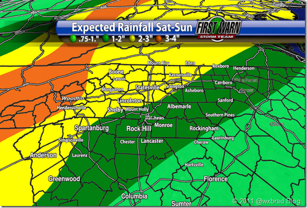 1-2 inches of rain for the Charlotte area's west of Charlotte will get hit harder: 2-3 inches of rain for most of the Mountains, even 3-4 inches of rain as you get closer to the Tennessee Boarder!
Friday, February 25, 2011
Possible Winter Storm For Southeast In Early March
Have you noticed the past few years it has snowed in the beginning of March? Well, it's a possibility that it could happen again this year. You may think spring is here for good and there will be no cold air, but according to previous winters, we do have that chance of some kind of wintry weather. There could be snow, sleet, ice, or there might be no more wintry weather at all, so stay tuned!
Here is what this(possible) March storm could look
like.
Here is what this(possible) March storm could look
like.
Subscribe to:
Comments (Atom)
