Monday, January 16, 2012

Snowfall/ Icefall Forecast for the Rest of the Winter for the Southeast

   There will be 4-6 snow events this winter. This could range from a few flurries, to heavy snow. There have already been 3 of these events, all of them being scattered flurry events in lower elevations. I think there could be a couple more of these scattered flurry events, by the time the month is over. There will be 1-2 major snow events. These kind of events would bring 4+ inches of snow. We have had none so far. I think early Febuary will be the best chance for snow for the Southeast. Other chances would be very late January, and possibly early March. I think NC, SC, eastern GA, and eastern TN would be the areas to watch the most. The Old Farmer's Almanac predicted "mild and snowy" for these areas.for these areas. I would agree with this, because these areas you would watch for a storm riding up the East coast.Everywhere else, it predicted "mild and dry". Still, don't give up. You can still get a storm moving from the West, or even better, a storm from the Gulf of Mexico. It all depends which storm track is the most common during this time frame. Anyway, I put slighty below average snowfall for central and southern MS and AL, and southern GA. I put average snowfall nearly the whole state of TN, except the eastern part of the state, and for northern and central MS, AL, and GA. I put the NC/TN line for the most snowfall, because of the much higher elevations there.


    I expect there to be 0-2 ice events for the Southeast this winter. These could occur anytime between now and early March. I think the largest threat of an icestorm would be central SC. I also put east central GA, central AL, and east central MS for a large chance of an icestorm. The mountains of NC, GA, and AL are under a low threat, because a lot of storms could be just all snow, since these areas will be colder than low elevations. I put western NC and SC under a small chance, because these areas will be warmer in a lot of situations, since they are so close to the coast causing there to be a lot of rain events. Southern GA, AL, and MS will also be under a small chance, since these areas are also commonly warmer.

Good News for Cold and Snow lovers? Talk of Greenland Block

   There has been some talk that a Greenland Block could start setting up very late this month. This talk has been from meteoroligists such as Joe Bastardi and Henry Margusity. I actually think this is more than a little "talk", and we could really have some blocking starting too setup very late this month. Some clues of a possible Greenland block would be what the GFS ensemble models are showing. They show that both the NAO and AO will both most likely be negative, by the end of the month. Last winter, both the NAO and AO were strongly negative at the same time. This caused lots of areas to have a very cold winter, with above average snowfall. A lot of records were set. For example, some areas that haven't had a white Christmas in over 50 years had a white Christmas last winter! Anyway, the NAO is expected to go negative around the 21st. This will only stay negative for a short amount of time, until around the 24th or 25th. Then it will go negative again around the 26th or 27th, and it looks to stay more negative this time. It will also drop more strongly negative, the mean of the models putting it between negative 1 and 2. Some models puts the NAO lower than negative 3! The AO goes negative within a few days. Most models keep it staying between negative 1 and two, but some models go even lower than that, one of them putting the AO even as low as negative 5 or 6!
   I think the best shot at snow will be early Febuary. The Old Farmers Almanac is saying this, and they are usually pretty accurate. Also, the new pattern will probably be more organized then. If this Greenland Block does setup, we will have more persistent periods of cold air. This pattern will be more favorable for snow. We will already have the first ingredient, cold air. Next, all we would need is a low to form. Just one good storm could bring a lot of areas near normal snowfaall.
   I also think early March could be a chance for snow too. A lot of years in the past, there have been a storm the first few days of March. We will have to keep a close eye on what happens this year.

AO Forecast

NAO Forecast


Monday, January 2, 2012

What Will the Rest of the Winter Look Like for the Southeast?

When to Expect Snow   
   There will be about 3 days of cold weather starting today. Then after that, warmer air will come in. There will be several days of above average temperatures. A lot of areas will see highs in the 60's again. Mid-January that will change. It will be much colder then. It also looks to possibly stormy. Mid-January and early Febuary I think are going to be the best chances for snow. I am now thinking there will be anywhere from 2-5 storms, instead of my earlier prediction that the Southeast gets 2-3 storms. Right now I'm thinking of lot of storms will be in the 1-4 inch range, but I'm not going to take out the chances of there being a storm in the 4-8 inch range, like last year.

   
What the NAO, AO, and PNA Are Showing
   The NAO, AO, and PNA is what I look I look at for cold air. The NAO will likley go negative mid-January. It is too early to tell how long it will stay negative. If it stays negative for a long time, expect much less periods of warth, and much longer periods of cold air. The AO is looking to possibly go negative too. This will enhance the cold air, when both the NAO and AO are negative. The PNA is currently positive, which is also a good thing if you want cold air. The only problem is that it will be negative by mid-January.

MRF Ensemble North Atlantic Oscillation outlooks
GFS Ensemble Arctic Oscillation Outlooks
   MRF Ensemble Pacific-North America Oscillation outlooks
   Signs Of Snow Already from the GFS
   There are already signs that mid-January could be snowy. There is snow showing up from the 13th to 14th for the Southeast, according to the GFS model. I know that the GFS sucks at long-ranged forecasts, but it has shown this storm the past couple of days.

GFS Hour 288

Primary Setup for Snow Events

   I think the primary setup for snow this winter will be that warm air is over us. We will start off as rain a lot of the time, and then it will change over to snow on the back end, where the cold air is. This is the kind of setup the GFS is showing fore the 13th-14th. I would expect snowfall to range from a trace to 4 inches in this kind of setup.


Secondary Setup for Snow

   I think a secondary setup for snow is that the cold air is in place, and a low forms. This would be the setup that we get all snow. This would give us a chance a the 4-8 inch snowfall I mentioned earlier in the blog. This kind of snowfall could happen if we have enough moisture and enough cold air. A strong storm coming out of the Gulf of Mexico, or a strong storm just off the East coast could easily give the Southeast this amount of snow. 


 Other Setups


   Another setup could be a messy mix of everything including snow, sleet, freezing rain, and rain. Another setup that has a pretty good chance of setting up is a icestorm. This kind of setup wouldn't depend on just the ground temperature, but also in the temperature above the ground. If there is a deep warm layer above the ground, expect freezing rain.

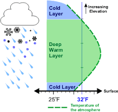
Setup for Freezing Rain