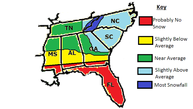
There will be 4-6 snow events this winter. This could range from a few flurries, to heavy snow. There have already been 3 of these events, all of them being scattered flurry events in lower elevations. I think there could be a couple more of these scattered flurry events, by the time the month is over. There will be 1-2 major snow events. These kind of events would bring 4+ inches of snow. We have had none so far. I think early Febuary will be the best chance for snow for the Southeast. Other chances would be very late January, and possibly early March. I think NC, SC, eastern GA, and eastern TN would be the areas to watch the most. The Old Farmer's Almanac predicted "mild and snowy" for these areas.for these areas. I would agree with this, because these areas you would watch for a storm riding up the East coast.Everywhere else, it predicted "mild and dry". Still, don't give up. You can still get a storm moving from the West, or even better, a storm from the Gulf of Mexico. It all depends which storm track is the most common during this time frame. Anyway, I put slighty below average snowfall for central and southern MS and AL, and southern GA. I put average snowfall nearly the whole state of TN, except the eastern part of the state, and for northern and central MS, AL, and GA. I put the NC/TN line for the most snowfall, because of the much higher elevations there.

I expect there to be 0-2 ice events for the Southeast this winter. These could occur anytime between now and early March. I think the largest threat of an icestorm would be central SC. I also put east central GA, central AL, and east central MS for a large chance of an icestorm. The mountains of NC, GA, and AL are under a low threat, because a lot of storms could be just all snow, since these areas will be colder than low elevations. I put western NC and SC under a small chance, because these areas will be warmer in a lot of situations, since they are so close to the coast causing there to be a lot of rain events. Southern GA, AL, and MS will also be under a small chance, since these areas are also commonly warmer.


how much would charlotte nc see?
ReplyDeleteI thinking in the 4-6 inch range, as of now.
ReplyDeleteso its really warm right now in charlotte nc so will it turn cold/snowy, im mean how r we supposed 2 hav 4-6 inches with 60 - 70 degree weather!!!!!!!!!!!!
ReplyDeleteThe pattern is going going to change early Febuary. Much colder for sure then. The NAO and AO go negative. There is also something called stratospheric warming that has resumed big time. This causes colder weather across much of the US. There is also something called the Greenland Block, which pretty much locks cold air over the east coast (Southeast and Northeast). The Greenland Block could also start setting up. And why has it been so warm? The NAO and AO has been strongly positive, and we need it to go negative for a favorable pattern for snow. Believe me, winter is coming.
ReplyDeleteya but winter is half way through so theres still some chance for snow to come (charlotte nc) woukd that only be 1 storm or 2 and how long will the cold stay when weve gotten cold air it only stayed for a couple days!so it would have to stay longer for good snow to fall and stay!
ReplyDeleteToo far out to tell how long it will last. And one good storm could give Charlotte good snow. From past experiences, I know that one good storm could give us average snowfall.
ReplyDeleteoh cool like 6 inches that would b a big one....so we are expected at least one good snow/cold?
ReplyDeleteYeah, thinking atleast one good storm. Maybe even more. And how long the cold lasts will depend on how long the NAO and AO stays negative. Still too early to tell how long the cold air will last, but there are some signs that it could last pretty long.
ReplyDeletelike would it go neg. early feb and stay till march , btw many people are saying it wont go neg till most of feb. thats bad right?
ReplyDeleteYes, it looks like the NAO probably won't be negative to Febuary, but I was looking at yesterday's NAO forecast, and it goes negative around the 22nd. We will just have to see. And yes, it is a possiblity that it will stay to early March. That would be bad if you hate snow and cold.
ReplyDeletehaha i dont, i hope we get snow when will it fall?and 22 of jan or feb?
ReplyDeleteFebuary be be favorable for snow, only if the forecast changes.....
Deleteany hope for snow coming up?charlotte nc?
ReplyDeleteYes, a probably more favorable pattern for snow late this month, or early Febuary. We will have to watch it closly.
Deleter we (charlottenc) gonna see any snow?this winter????????
ReplyDeleteProbably, yes. A way more favorable pattern for snow is coming in Febuary. Much colder for sure, but way too early to get a handle on any storms.
ReplyDeletehow come we Charlotte NC haven't seen any snow?are we going to this winter..?and why has the groundhog said 6 more weeks of winter if winter never really started?plus Charlotte's groundhog said 6 more weeks of winter 2 do we have any luck 4 some snow?!!!!!!!!!!!
ReplyDeleteYes, going into late week/next weekend, it is going to get much colder. The question will be if the cold air and moisture will meet up. This colder pattern could last anywhere from 1 week to 2 weeks.
Delete